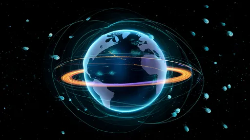
The vast, ever-changing nature of Earth's oceans has long presented challenges for scientists, mariners, and climate researchers alike. Now, a groundbreaking technological advancement is revolutionizing our understanding of marine environments through digital ocean twins - highly sophisticated real-time simulations of global ocean currents that mirror their physical counterparts with unprecedented accuracy.
These virtual ocean models represent more than just academic exercises in fluid dynamics. By combining satellite data, underwater sensor networks, and advanced computing power, researchers have created living digital replicas that update continuously, providing an interactive window into the complex dance of ocean circulation patterns that shape our planet's climate and ecosystems.
How Digital Ocean Twins Work
At their core, digital ocean twins function by ingesting massive amounts of observational data from multiple sources. Satellite altimeters measure sea surface height to within centimeters, while fleets of autonomous underwater gliders and floating sensors collect temperature, salinity, and current velocity data at various depths. This constant stream of information feeds into supercomputer-powered models that solve the complex equations governing fluid motion across planetary scales.
The computational frameworks behind these simulations have evolved dramatically in recent years. Where older models might update weekly or monthly, current systems can incorporate new data hourly or even continuously, creating a dynamic digital mirror of the ocean that evolves in lockstep with reality. Advanced machine learning techniques help fill gaps between physical observations, while high-resolution grids capture eddies and currents down to scales of just a few kilometers.
Applications Across Industries
Shipping companies are already using digital twin technology to optimize routes, saving millions in fuel costs by riding favorable currents while avoiding counterflows. A recent trans-Pacific voyage guided by these models demonstrated a 12% reduction in fuel consumption compared to traditional routing methods - significant both economically and environmentally.
Climate scientists find particular value in these simulations for understanding heat distribution across the planet. The oceans absorb over 90% of excess heat from global warming, and digital twins provide an unparalleled view of how this energy moves through marine systems. Researchers can track warm water pulses that influence hurricane formation or follow deepwater upwelling events that drive regional weather patterns.
Fisheries management represents another critical application. By modeling how currents transport nutrients and plankton - the base of the marine food web - these systems help predict fish migrations and spawning grounds. Several countries have begun incorporating digital twin data into sustainable fishing quotas and marine protected area planning.
Technological Challenges and Breakthroughs
Creating accurate global current simulations requires overcoming substantial technical hurdles. The ocean operates across multiple interacting scales, from basin-wide circulation patterns down to turbulent eddies just meters across. Early models struggled to represent this complexity without requiring impractical computing resources.
Recent advances in adaptive mesh refinement have helped solve this challenge. These techniques automatically increase resolution in areas of particular interest or complexity while maintaining coarser grids in more stable regions. Combined with GPU acceleration and distributed computing architectures, modern systems can now simulate the global ocean at resolutions unimaginable a decade ago.
Data assimilation presents another critical innovation. Rather than treating models and observations separately, digital twins continuously adjust their virtual currents to match real-world measurements. This self-correcting capability keeps simulations accurate even when initial conditions contain uncertainties or when unexpected events like underwater landslides disrupt normal flow patterns.
The Future of Ocean Prediction
Looking ahead, researchers envision digital ocean twins becoming increasingly interactive and accessible. Some projects aim to develop public-facing interfaces that allow students, journalists, and policymakers to explore current patterns and run "what-if" scenarios. Imagine adjusting wind patterns to see how climate change might alter major currents, or simulating the spread of pollution from hypothetical spills.
Integration with other Earth system models represents another frontier. Coupling ocean twins with atmospheric and land-surface simulations could enable complete planetary-scale environmental monitoring. Early experiments linking ocean and weather models have already improved hurricane intensity forecasts by better representing the heat exchange between air and sea.
Perhaps most importantly, these digital replicas serve as crucial tools for understanding and mitigating climate change. By providing an unprecedented view of how oceans store and transport heat and carbon, they offer insights into everything from sea level rise to ocean acidification patterns. As the technology matures, digital ocean twins may well become indispensable for navigating the challenges of our changing planet.
The development of real-time global current simulations marks a paradigm shift in ocean science. No longer limited to static models or delayed observations, researchers now have access to a dynamic, evolving digital representation of Earth's marine environments. From protecting ecosystems to guiding ships and predicting climate impacts, digital ocean twins are transforming how we understand and interact with the blue heart of our planet.

By /Aug 5, 2025

By /Aug 5, 2025
By /Aug 5, 2025

By /Aug 5, 2025

By /Aug 5, 2025

By /Aug 5, 2025
By /Aug 5, 2025

By /Aug 5, 2025

By /Aug 5, 2025

By /Aug 5, 2025

By /Aug 5, 2025

By /Aug 5, 2025

By /Aug 5, 2025

By /Aug 5, 2025

By /Aug 5, 2025

By /Aug 5, 2025

By /Aug 5, 2025

By /Aug 5, 2025
By /Aug 5, 2025

By /Aug 5, 2025